HIKING IN GALAPAGOS: A Day Solo in the Highlands of Santa Cruz
Text & Photos: Andreea Lotak · 15 min read
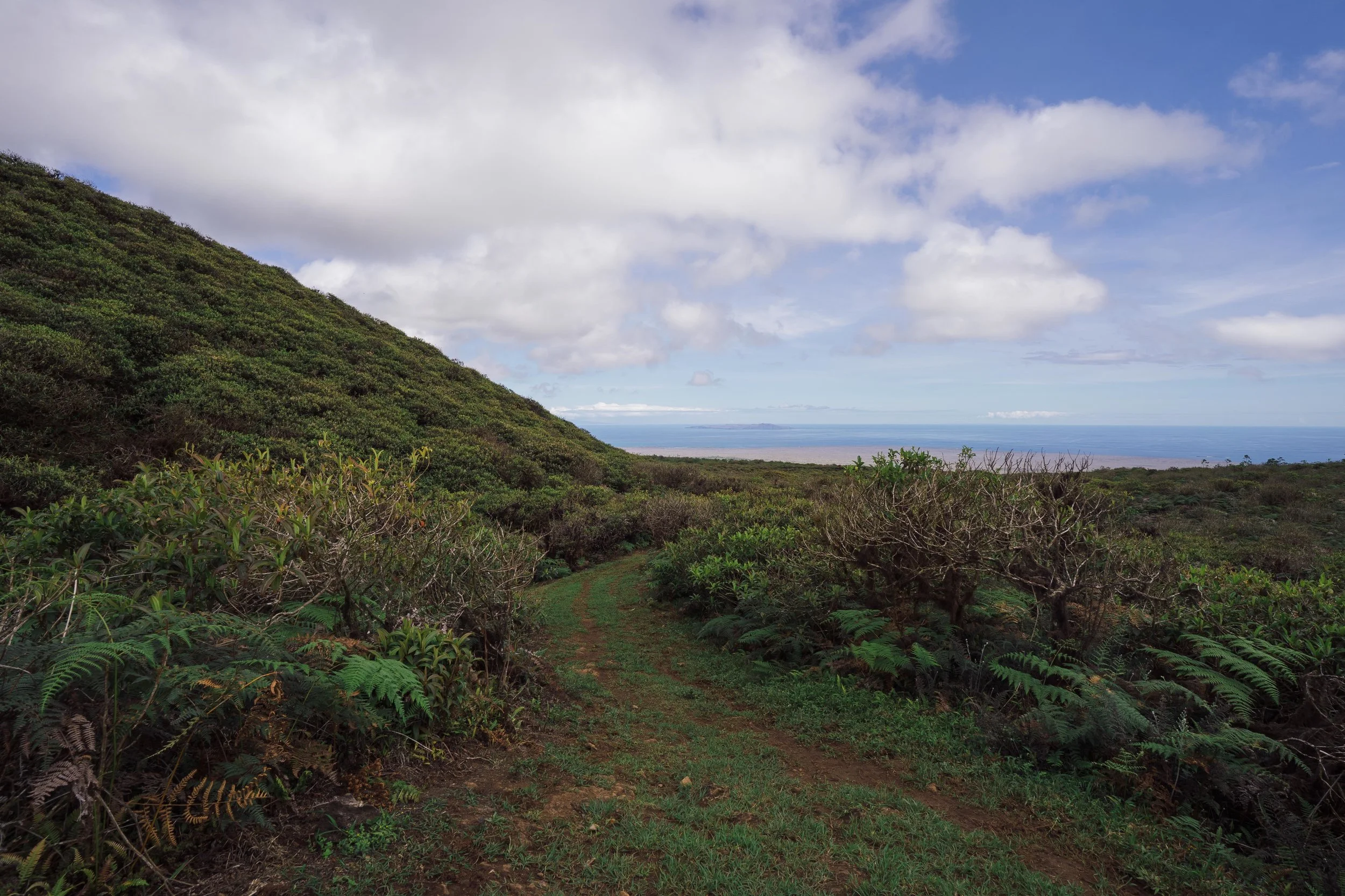
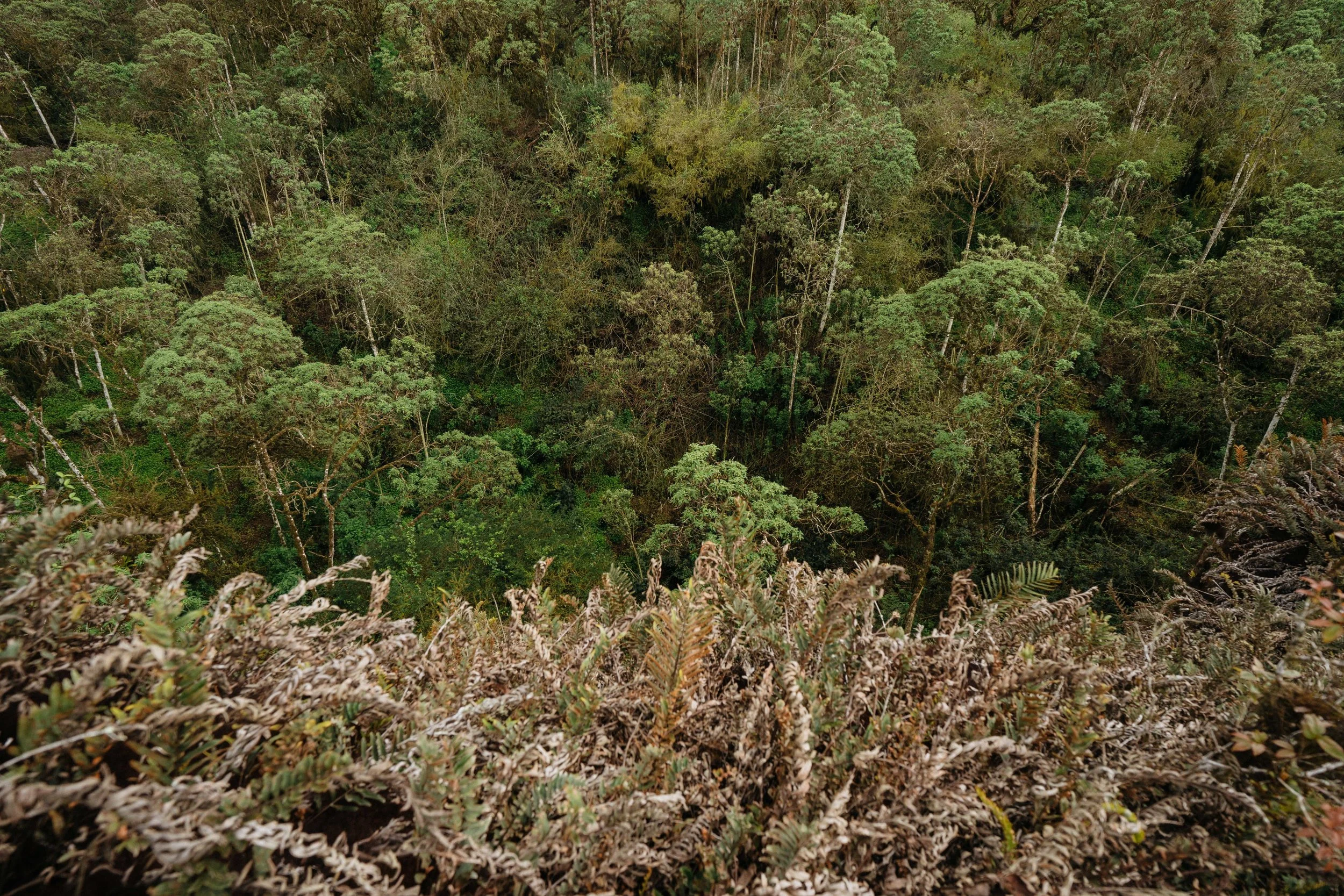
View from the trail up to Cerro Crocker
From the boat anchored in Academy Bay I would look up every morning at the silhouette of Cerro Crocker, the highest peak on the island, and at the lush vegetation of the highlands almost always covered in clouds. Soon I’d be making my way up there, escaping the dryness of the coast for which Galapagos is famous.
At the bottom of the page there’s a summary of the most important useful facts regarding this day in the highlands of Santa Cruz.
It had been almost three weeks of constantly feeling covered in sea salt, and I was happy to be preparing for the hike into the rainy highlands. I drank a coffee, finished packing the necessary items for a day-long trip, threw in a few extra granola bars just in case, and tried to put aside the fears others had expressed about my solo hike. The night before, two of the new-found friends in Puerto Ayora set out to tell me terrible stories about hikes that went wrong in the past, from a Chilean rescued by helicopter to an Israeli man whose body was found much later in a mangrove down the coast as they were trying to find their way through the highlands. To be clear, this is not a story about an exciting adventure where things go wrong, to then be twisted around for the better. It’s a story of how you can do a solo hike in a wonderful landscape without any troubles and make the best out of your taxi rental (#disappointing music sound#). Though I was prepared with a GPS, some extra food, a compass, along with some mental images of myself covered in mud and wandering through the woods late at night while strategically planning on heading towards the peak to find my bearings and then return to write a story about it all, nothing went wrong. Probably for the best, since soon after the start of the trip I realized I had forgotten the two items I never leave behind on a hike: my headlamp and the pocket knife.
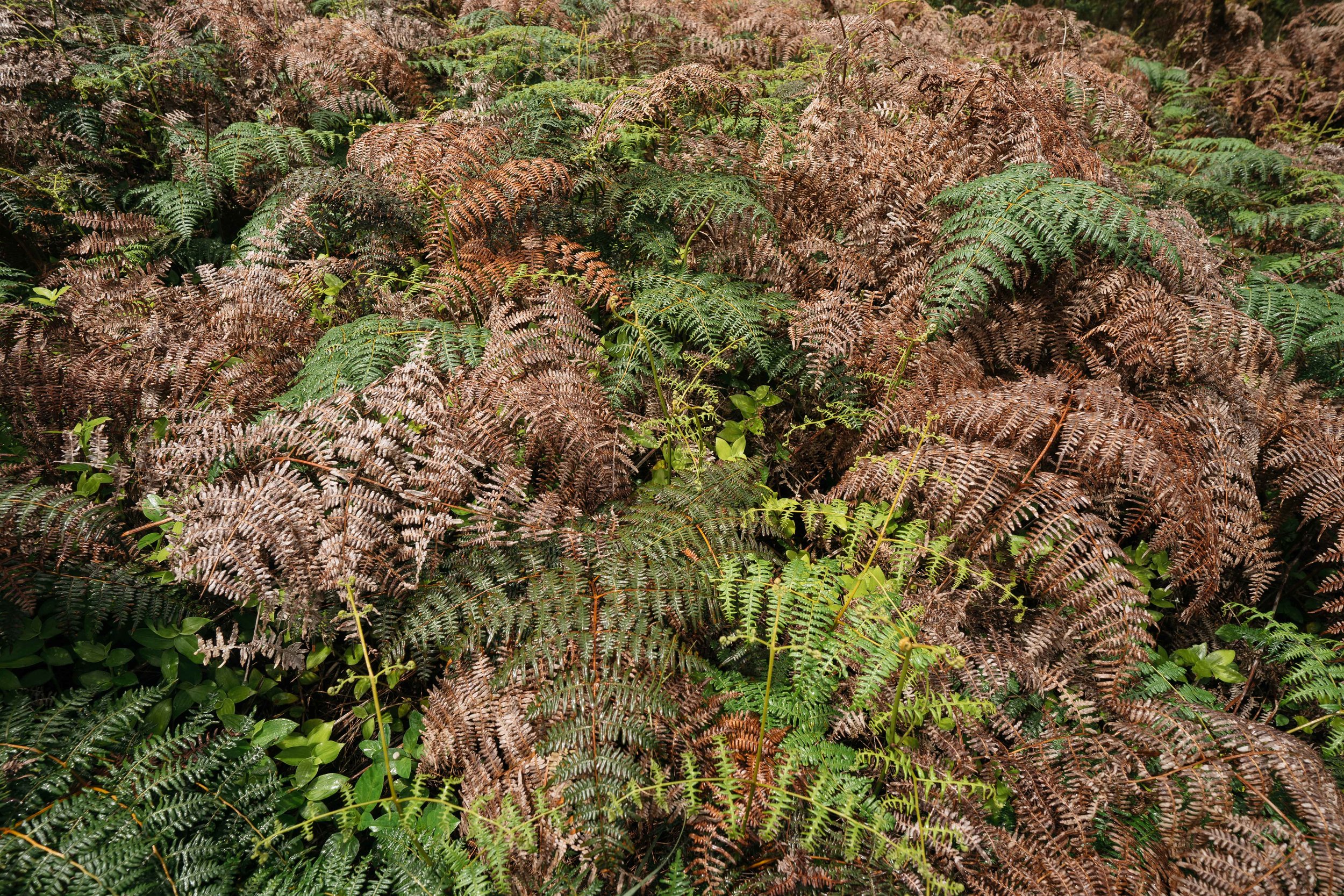
At only 864m, Cerro Crocker is not an intimidating mountain, but it is the highest peak on the island. The ever-changing weather with heavy rains and fogs during the wet season (typically December - May) can make the trek difficult. The vegetation on the southern side of Santa Cruz is very fractioned by the increase in altitude and by climate zones. The coastal areas are dominated by the mangrove forests where marine iguanas, sea turtles and herons roam. This is followed by the larger arid zone with strange-looking cacti and thorny bushes and trees which goes up to about 150m. Once you reach 500m, the landscape is covered in wet and foggy endemic Scalesia forests. Keep gaining altitude and at about 700m you’re surrounded by another endemic plant - the Miconia shrub. Go past it and you enter the Fern-sedge zone with an incredible variety of ferns and small shrubs and grasses (more here). I’m not an expert in plant names, but there aren’t many things that can make me more excited than seeing lush mosses and fungi, along with bog and twisted trees covered in epiphytes. If the highlands were what I was imagining, then I was about to have a great day.
Some technicalities - almost all activities on the Galapagos islands are regulated and have to be booked through an agency as part of a guided tour. There are few places where one can wander independently and that is done to protect these unique lands and to control the number of people visiting at one time. The highlands region was covered in confusion just as much as it was covered in clouds. The Visitor Center in Puerto Ayora explained that since Cerro Crocker and Puntado are part of the national park I would need a guide. Travel agencies said that it can be done independently. The only travel information to which I had access was a Moon guidebook on the Kindle which also said it can be done independently. Another issue was trying to get a clear description of the hike from people in town. Everyone had done it, but at least some 10 years before. Everyone advised caution, too. Plus, the internet was so slow that I had abandoned the mindset of searching information there, which was unfortunate because this post right here explains it quite nicely and would have spared me of that wrong turn I was bound to take.

I arranged with a reliable taxi driver to pick me up around 10:00 am from downtown. The cost for a half day drive to several sites was $70 and it was one of the cheapest things I did the time we were there. If more people are joining and sharing the cost, then it truly is a good deal by Galapagos standards. There are options of doing some of these activities by bikes rented in Puerto Ayora. There's a really nice separate bike lane up to Bellavista, but it's uphill and it's a rainy area. Past Bellavista the lane narrows and continues along the road. If you're in shape and don't pack all the activities in one day, it's probably the ideal way to visit the heights of Santa Cruz. Unfortunately I had less than 5 hours to do it all.
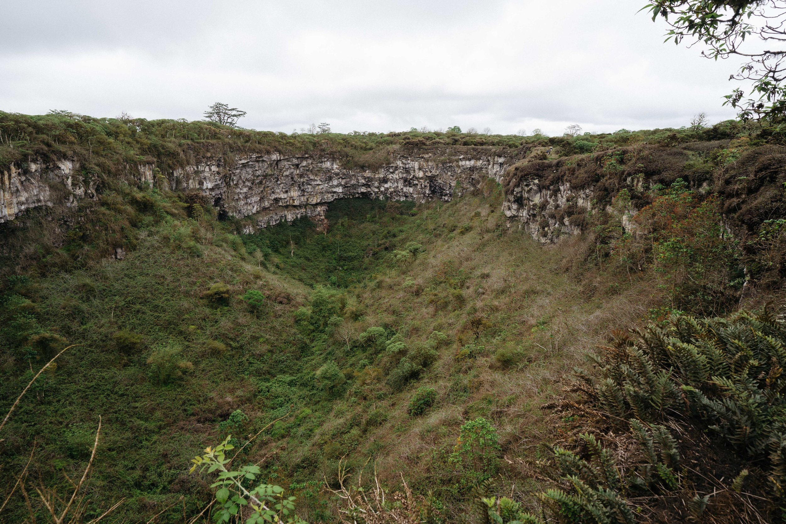
FIRST STOP: LOS GEMELOS/THE TWINS
These are giant sinkholes in the magma that collapsed due to tectonic activity. They are located on each side of the road but are well hidden by dense vegetation. Looking into the depth of the first sinkhole covered in Scalesia trees was mesmerizing. I encountered very few people here, especially considering the accessibility of the site. Soon after I took a loop trail through a forest of Guayabillo trees with twisted branches it started raining, which contributed to the charm. Guayabillos are a native species of trees which the IUCN classifies as Vulnerable, “facing a great risk of extinction in the wild”. All throughout the Galapagos native and endemic vegetation is at risk of disappearing due to invasive species, like the guava and quinine trees. The sign on the trail recommends silence while walking, as finches, short-eared owls and flycatchers can be spotted. The extreme beauty and eeriness of the plant-life in this cloud forest could quiet down anyone, anyway. What would have taken a few minutes to loop back on the main trail took me about half an hour of taking pictures and marveling at ferns, orchids, trees and birds. Once back I made it to the last lookout where the trail ends and you can take a closer look at the canopy of Scalesia. I returned to the road, crossed and took the other trailhead to the east-side sinkhole. There the path is much shorter and takes you right away to the parking lot where my new friend, Antonio, was waiting in the car.
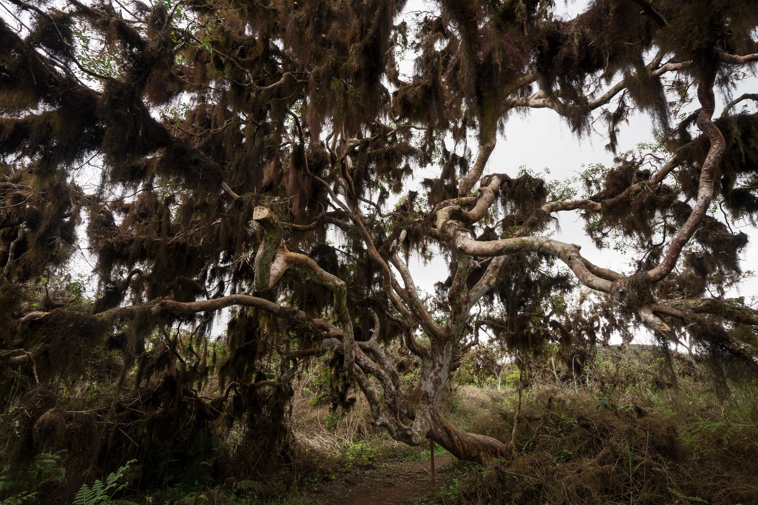


One of the impressive Guayabillo trees at Los Gemelos
SECOND STOP: EL CHATO RESERVE
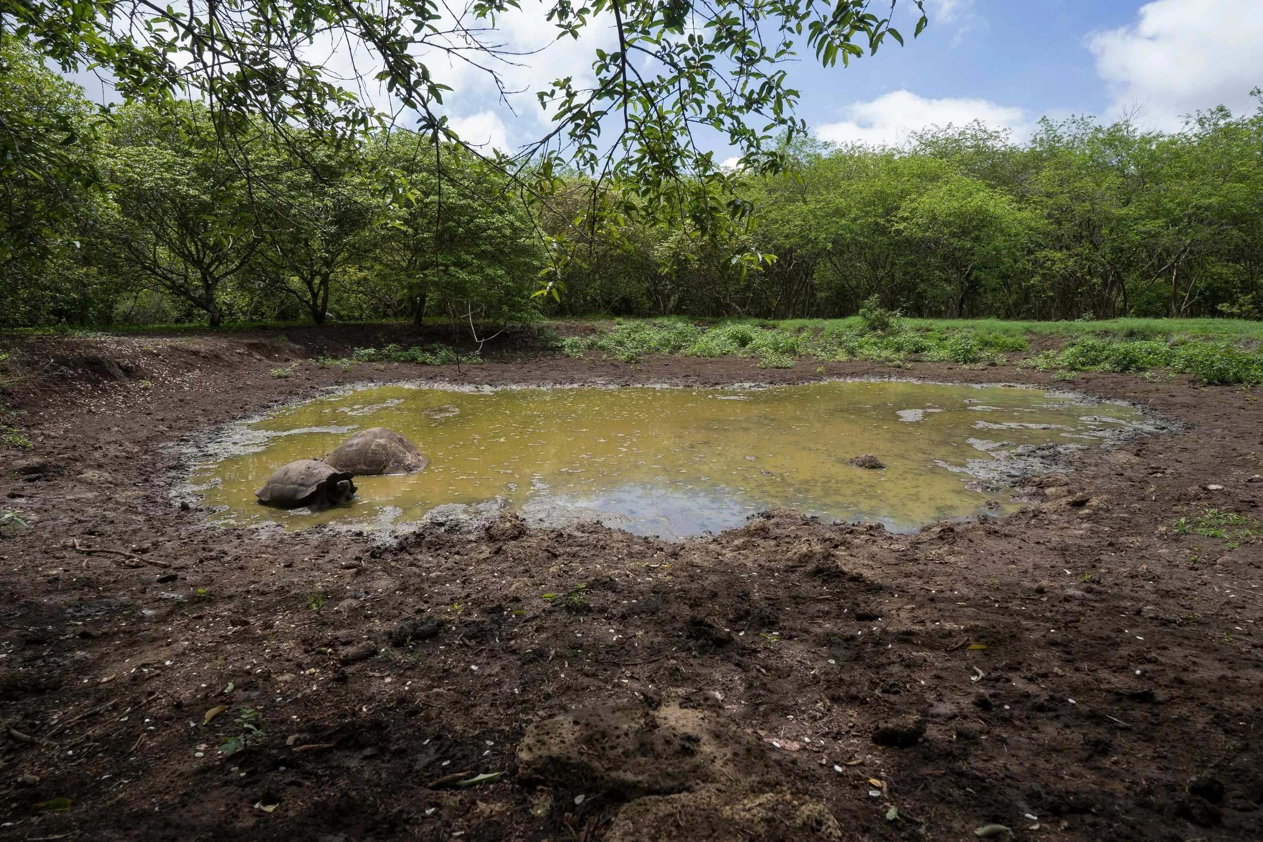
A short 15 minutes ride got me to El Chato. A tract of private land of about 12 ha, the reserve is now home to a large number of Santa Cruz giant tortoises. The national park borders it, so the tortoises move freely from the park into the reserve and vice versa. Plus, right next door there is another huge private reserve called Rancho El Primicio. This is one of the best opportunities available to come close to these giant animals in their natural habitat. We had learned from a park ranger that the national park has a type of ecological easement called a serviduria ecologica. It’s an incentive program that allows landowners to voluntarily host giant tortoises on their property while the park insures that everything is done correctly for the wellbeing of the animals, including minimal human intrusion, healthy food, mud ponds, and a clean habitat. In exchange, the landowners can charge a fee for visitors coming to their lands if they choose to open them for the public. Access to El Chato was only $3 per person. For a similar price you can also visit Primicio if you want to dedicate the day to seeing the most emblematic species in the archipelago. I must have spent about an hour here. It’s best to avoid going between 1:00pm - 4:00 pm when all tortoises are seeking shade and slow down their already sluggish pace. I walked around and explored the inside of some of the lava tunnels on the property and stared in awe at tortoises. All in all I saw only a small percentage of the place but got what I was looking for. At one point I put the camera down, sat in the grass at a respectful distance of about 2m and just looked at a Santa Cruz giant male tortoise (C. Porteri) eating grass. Eventually he took notice of me, raised his head slowly breathing, then after what might have seemed like a fraction of a second in his infinite time, gently turned around, lifted his shell a bit and left a big dropping. I took this as a cue to move on and kept walking around a mud pond where a couple was getting ready to cool off for the afternoon, then slowly made my way back where Antonio was waiting for me.

Third stop: Cerro Crocker & El Puntado Area
Finally, I was on my way now to the trailhead for Cerro Crocker and El Puntado. We went back south towards Bellavista, where a turn to Media Luna got us on a steep dirt road. It was around 1:00 pm. The first of the confusing facts was clarified - it is possible to get by taxi all the way up the dirt road, close to the trailhead. That takes away a total of some 5 km from the hike, which meant that I could have time to make it to the peak.
Once on my way up, the clouds were starting to gather on the side of the mountain, but towards the coast it was clear. I got to a sign a few minutes later, welcoming me to the Cerro Croker and El Puntado area. The very basic map with just the white lines of the trails on a dark background didn’t seem very helpful but it did put a smile on my face. "Left for Puntado, right for Crocker once I’d get to a fork in the road. Easy". As I kept going I found myself surrounded by Miconia shrubs. They can grow up to 5m and are an essential habitat for the critically endangered Dark-rumped petrel and the Galapagos rail. The Miconia itself is greatly endangered, mainly due to the competition with guava trees and quinine. This vast patch of vegetation reminded me a bit of the laurels and rhododendrons of the forests of the US East Coast. The rather muddy trail had lots of footprints on it. The many horse hooves got me worried for reasons that escape the mind of any normal human being who is not afraid of horses, of all creatures. But I am, so deep down I hoped that I wouldn’t cross path with them. Instead I encountered another hiker returning from Cerro Crocker and saying it’s another hour up from there and then an hour and a half to the trailhead but that it wasn't a hard hike. Since I had limited time I decided to go instead to El Puntado, the other, less visited peak. I got to a what looked like a fork in the road and kept left to reach Puntado as I had seen on the map. First confusion. Though once on the trail it seems hard to imagine getting lost unless the clouds and fog are really dense and it’s raining, there are numerous smaller or bigger trails spurring off the main one. Additionally, there are no markers. The main trail is wide and hard to lose in normal conditions though.
As I now know, I was still on track when I kept left at this first fork. Another 15 or 20 minutes of taking too many pictures of the incredible landscape and I got to another fork marked by a sign explaining more about the elusive petrels living in the Miconia. A trail around it to the left looked like an abandoned one. Since I thought I had already taken the turn towards Puntado I decided to keep right on the wide trail and continue upward. At this point I had been on the trail probably
for some 40 minutes. Soon I passed two green houses which belong to the national park, where I saw no sign of humans. Some 20 more minutes later I had to consider starting my way down soon in order to make it back on time. I could clearly see the peak of Cerro Crocker ahead of me, with the weather station and the telecommunications antenna, but Puntado wasn’t in sight. I kept thinking that at the next turn I would see it, but at this point I was aware something wasn’t right. However, though hard to accept that I had started a hike without making it to the peak, the journey itself was perfect. It was quiet, the sky was clearing up and I could see the coast, the ocean and the other islands in the distance. All around me ferns were dominant, and cute, yellow warblers were making their calls from the branches of strange tree stumps covered in moss. I got to a high point, took a few more pictures and celebrated with some lukewarm water and an apple, and then started heading back.
Reverse a little to clarify - I had turned right at the Petrel sign, which turns out is the actual fork marked on the basic map at the start of the hike. So I was headed instead to Cerro Crocker, missing the opportunity of summiting one of the peaks on the island. That less traveled, narrower trail to the left side of the Petrel sign is the trail to Puntado. It doesn’t matter much. The solitude and beauty of the area was revealed to me regardless of summiting. It's one of the top experiences I had in the Galapagos. The fact that it’s so off the beaten path and the fact that I’m a Romanian going up there makes me think I’m part of a very small demographic. For some reason this matters (don’t judge). On a more serious note, this ecosystem is a highly fragile and highly endangered one. It’s the only way of seeing the Miconia and Fern-sedge zones with their flora and fauna. The fact that the national park opened up this small part to the public is a great gift for others like me looking for unique habitats, relatively off the beaten path.
I was back to the car at 3 pm, making this a 1 h 40 mins hike. Had I gone left at the Petrel sign, I would have had time to summit Puntado. From the trailhead there are some 15 minutes by car to get back to Puerto Ayora, passing by the small and green Bellavista. At the end of it my boots were caked in mud and I had a wide smile on my face while sweat was dripping in my eyes. It was a wonderful way to spend half a day on Santa Cruz, seeing its less explored ecosystems. Below you'll find the summary of the important facts to know if you decide to do these activities.


SUMMARY OF USEFUL INFO:
Activity: Wildlife watching & hiking in the Highlands of Santa Cruz; ~ 5 hrs
Cost: $70 taxi rental + $3 entrance fee at El Chato
Access to food and water: Limited, but El Chato has a restaurant where you can grab a meal and refill on water; best to come prepared
TO BRING:
sturdy hiking shoes/boots;
an extra pair of socks or a pair of hiking sandals
rain coat and cover for backpack. All in all be ready for wet conditions because it will probably rain at least for a small part if you’re doing this in the wet season
food & snacks, water (brought 2 bottles; 1l + 1.5l)
cash ( total cost $73 but you might want to refill on snacks or drinks)
hiking poles could be useful in rainy conditions coming down
headlamp & pocket knife should always be in the pack
compass
camera gear if you want to capture what you’re seeing
couldn’t find a topo map of the hike, but if you have one that’s great
Since these are activities that can be done without a guide, we have to be mindful of our actions while alone on the trails. Birds are nesting on the ground, so walking off the path can destroy their eggs and nests. Breaking plants that are endangered is definitely not a good souvenir. Leaving any garbage behind, even fruit or vegetables, is clearly a bad idea in a very fragile environment. Enjoy with gratitude this opportunity of being on your own in the Galapagos.
"We call Galapagos a ‘social ecosystem’ - the union of the community with the ecosystem’s management, which is what generates conservation." Interview with Christian Sevilla, responsible for the Conservation and Restoration of Island Ecosystems department within the Galapagos National Park.
Intact ecosystems and their continuous conservation are something that an increasing number of people are willing to pay to witness, and whether for their endemic species, evolutionary importance, or rich biodiversity, many islands around the world claim to be different regions’ “Galápagos”.
"When you go to dive you have privacy and the fishes have peace, and you don't have a 'New York' underwater." Interview with Mathias Espinosa, co-founder of Scuba Iguana, the oldest operating dive company on Santa Cruz Island.
We were greeted by pristine, blue and shallow waters filled with marine life, while the unpaved streets of the town promised a more quiet experience than the one on San Cristóbal or Santa Cruz.
From the boat anchored in Academy Bay I would look up every morning at the silhouette of Cerro Crocker, the highest peak on the island. Soon I’d be making my way up there, escaping the dryness of the coast for which Galapagos is famous.
Visiting the Santa Cruz Island with its budget-friendly options, conservation hot-spots and the incredible day trip to the Seymour Norte island.
It had been six days of open ocean when one early morning we woke up with land in sight. From the misty air and foggy, rugged landscape of what looked like a barren island it was easier to think we had reached some mysterious lands up North rather than at the Equator. Once we sailed past the majestic silhouette of the Leon Dormido rocks it was less than an hour that we’d make our entrance in the bay of Puerto Baquerizo Moreno, San Cristobal.
We arrived to the Galapagos Islands by sea, following a similar trajectory that many of the species that call these islands home may have taken tens of thousands of years ago.