“NEW ZEALAND’S TRAIL”: Our Journey on the South Island in Photographs
Text: Andreea Lotak; Photos: Justin & Andreea Lotak · 8 min read

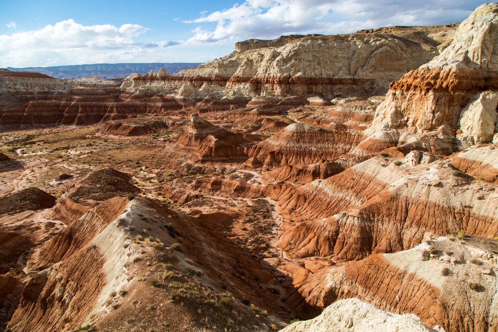
The Long Hilly Track was our first introduction to the stunning forests of New Zealand’s South Island. Originally a gold mining region, it is now known as the Longwood Forest Conservation Area, which protects natural and historic resources. After an 8 hour walk we made our way to the first hut on the trail, Martin’s Hut.
Te Araroa, meaning “the long trail” in Mãori, is quickly growing in popularity, bringing people from all over the world to witness the wild beauty of New Zealand along a 3,000 km journey from the tip of the North Island to the bottom of the South Island.
At the beginning of 2018 we began our 1.5 month backpacking journey along sections of the Te Araroa on the South Island, looking to document its landscapes, wildlife and the stories of some of the thru-hikers. As long distance trails are captivating the imagination of more and more people and are starting to appear in remote places around the world, we were interested in learning how these initiatives connect different conservation lands, ecosystems and communities, allowing hikers to experience a deeper immersion within the living landscapes that they cross at the pace of their walking. With backpacks strapped to our backs and an itinerary that we try to cover day by day, it’s easy to turn long distance hiking into a race to cover as much ground as possible, as fast as possible. The record for completing the 3,000 km of the Te Araroa belongs to Jez Bragg, famous ultra-marathoner, and was done in 53 days of running with support from a crew. This year there were several people on the trail trying to beat different records, while others were pushing to finish as fast as possible, carrying only minimal equipment. The athletic component of long distance trails is, though, just one aspect. At the other end there are the people who are taking their time to reflect and absorb the experience fully. We were interested in the idea of the connection with the natural world and to a simpler lifestyle. This lifestyle is often rewarded by the serendipitous human interactions with the community of hikers and trail angels. The stories we collected from interviewing hikers will be the subject of an upcoming project. For now we want to share a selection of photographs that strive to capture the natural beauty of New Zealand’s South Island along the Te Araroa. The idea is to encourage all thru-hikers, future and past, to reflect upon the opportunity given by a long distance trail to learn more about the importance of the ecosystems experienced when spending so many days in the outdoors. The more we learn about them, the more we pay attention to protect these places and appreciate their complex beauty. New Zealand is home to impressive endemic species, and often on the trail we can encounter unique birds and plants of New Zealand which we wouldn’t see anywhere else on Earth. It’s worth giving them a piece of our time. Through some of the photographs collected on the trail, we invite you to immerse yourself for a few minutes in the magical natural world of the Te Araroa.
PS: Te Araroa has its own slang, like most long distance trails. The trail is often referred to as the TA. In New Zealand a hiker is called a tramper, hiking is tramping, and a trail is a track. Those starting their journey northbound are known as NOBOs. For the south-bounders, the term is SOBO. The Department of Conservation managing most conservation lands and huts along the Te Araroa is simply known as DOC (pronounced as “doc”).
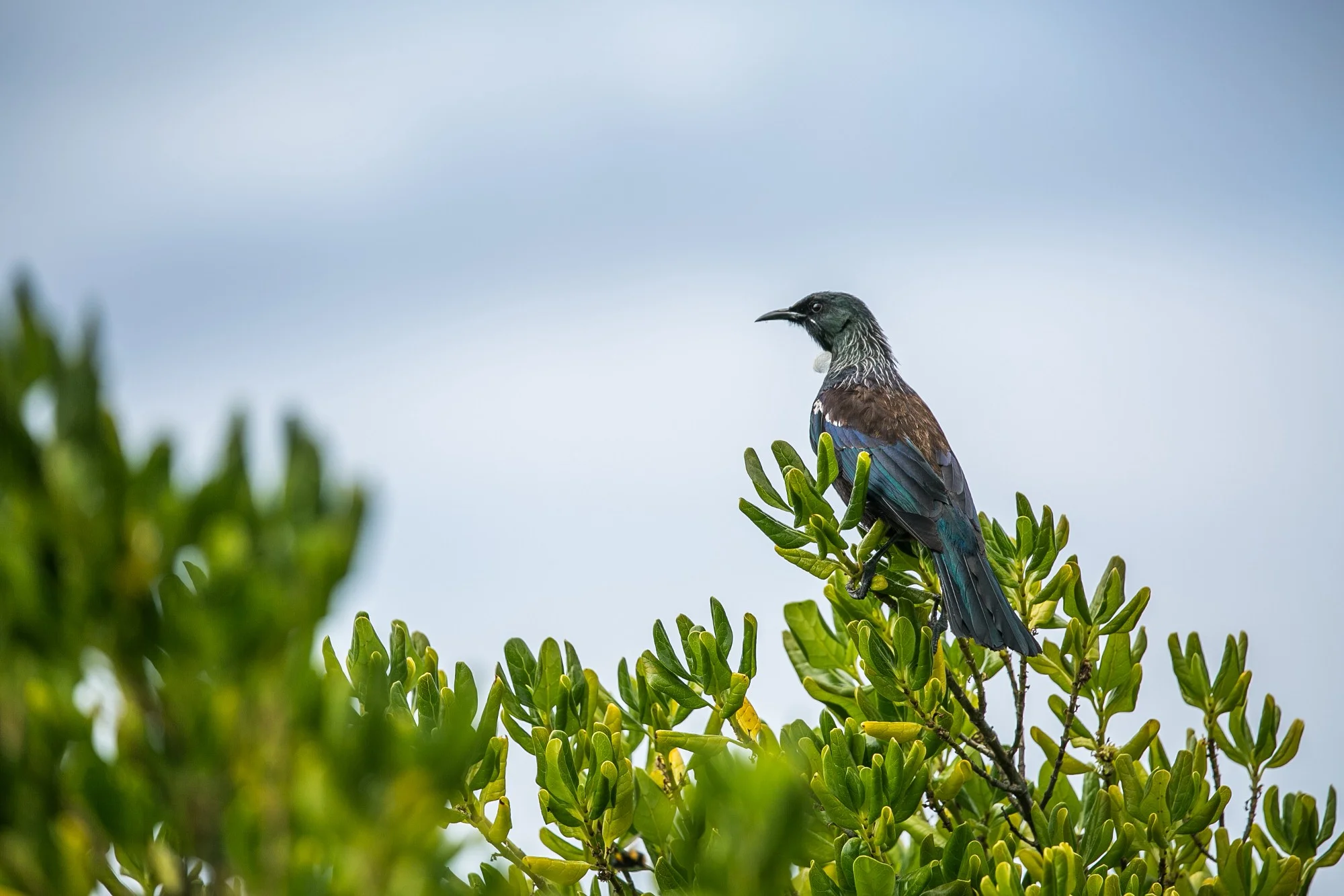
A Tui bird, one of New Zealand’s iconic forest denizens, right past the Foveaux Walkway trailhead outside Bluff. Tui birds are part of the honeyeater family, and are endemic to New Zealand. Their surreal calls early in the morning seem to come from another planet, and the Māori used to train them to replicate complex speech patterns. Tui, unlinke many other endemic bird species in New Zealand, have adapted better to the changes brought by human habitation on the islands and continue to be wide-spread.


We were lucky to start our hiking northbound (or “NOBO” in Te Araroa terminology) with excellent weather from Bluff. The small town of Bluff is a quaint place, with a nice campground and an international fame for the local oysters. In clockwise order from above: the Stirling Point lighthouse; the famous sign at Stirling Point which marks the southernmost start or end on the Te Araroa; the walk back into Bluff on the way to Invercargill; the beautiful view from the Bluff Hill Lookout.

Justin taking a picture of the landscape on the Foveaux Walkway, the first track section on the TA when heading north. This February, half of this track continued to be closed to the public and an alternative route was used. It took us uphill to the Bluff Lookout, then back to town along a steep, paved road.

Left: The 22 km walk along Oreti Beach between Invercargill and Riverton/Aparima is beautiful and surprisingly tough. After some time every muscle in your feet will probably start hurting if you are northbound, at the beginning of your trek. Right: The charming Riverton/Aparima town on the way to Colac Bay. With a population of less than 2,000, a nice hostel downtown and some cafes, it is one of New Zealand’s oldest towns and a nice day stop along the TA.
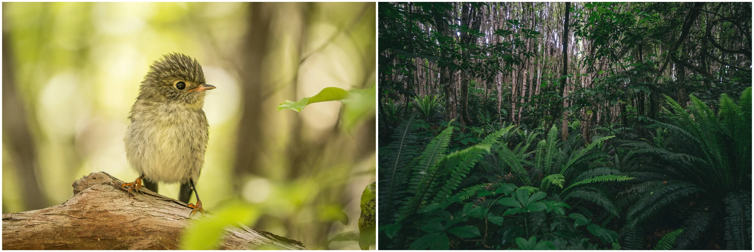

Top left: A juvenile tomtit greeting us in the forests above Bluff. Top right: The dense, dark woods of the Longwood Forest Conservation Area. Bottom left: Trees make way to patches of ferns along the Longwood Forest Track. There are approximatley 200 species of ferns in New Zealand, with the most iconic being the silver tree-fern. Bottom right: A male tomtit, known by its Māori name as “miromiro”. They are mostly forest and brush dwellers, seldom seen in open-country farmland.

On the way to Bald Hill, the Longwood Forest Track crosses through tussock and peat bogs, then winds back into a truly magical forest where mosses and lichens cover every tree.

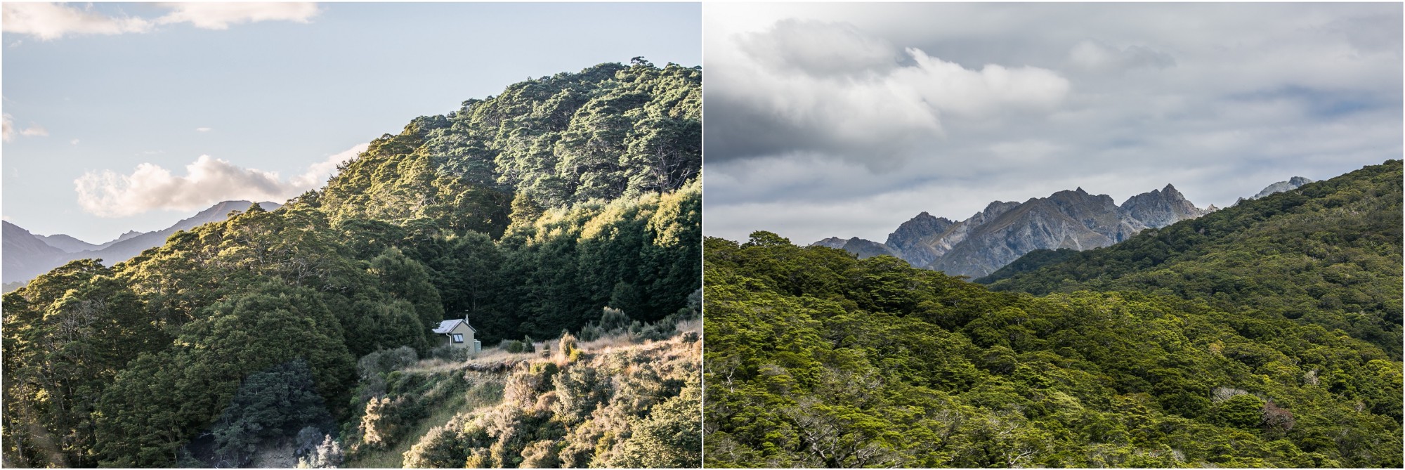
Between the Bald Hill and the Mt Linton sections of the TA we took a break at the Birchwood Station farmstay. The family has recently opened up the house dedicated formerly to the sheep shearers to now be used by TA hikers. It’s a great place to relax, do some laundry, resupply in the nearby towns and maybe opt for a delicious dinner cooked by the host. This area displays a tamed landscape of large sheep farms, with wild mountains rising in the background. The Mount Linton Station pictured here is one of New Zealand’s largest, and a 25 km section of the TA runs through it on the way to the Telford Campsite.
Left: The Aparima Hut surrounded by dense native forest. There are over 70 huts along the Te Araroa and hikers can purchase a 6-month pass to spend the night in them or to camp outside. Some are brand new, some carry the marks of a longer history, but they are all charming and a welcomed sight after a long day of hiking, especially if rain is in the forecast. Often there is no warden, so a system of honor is in place and visitors are trusted to have a pass or a ticket for the night. The money helps maintaining this impressive hut system and goes toward the Department of Conservation (DOC) and their work to protect New Zealand’s natural treasures. Right: Leaving the Aparima Hut on the way to the Lower Princhester Hut, the Takitimu Track makes its way trough tall tussock within the Waterloo Station, and through rough terrain inside beech forests.
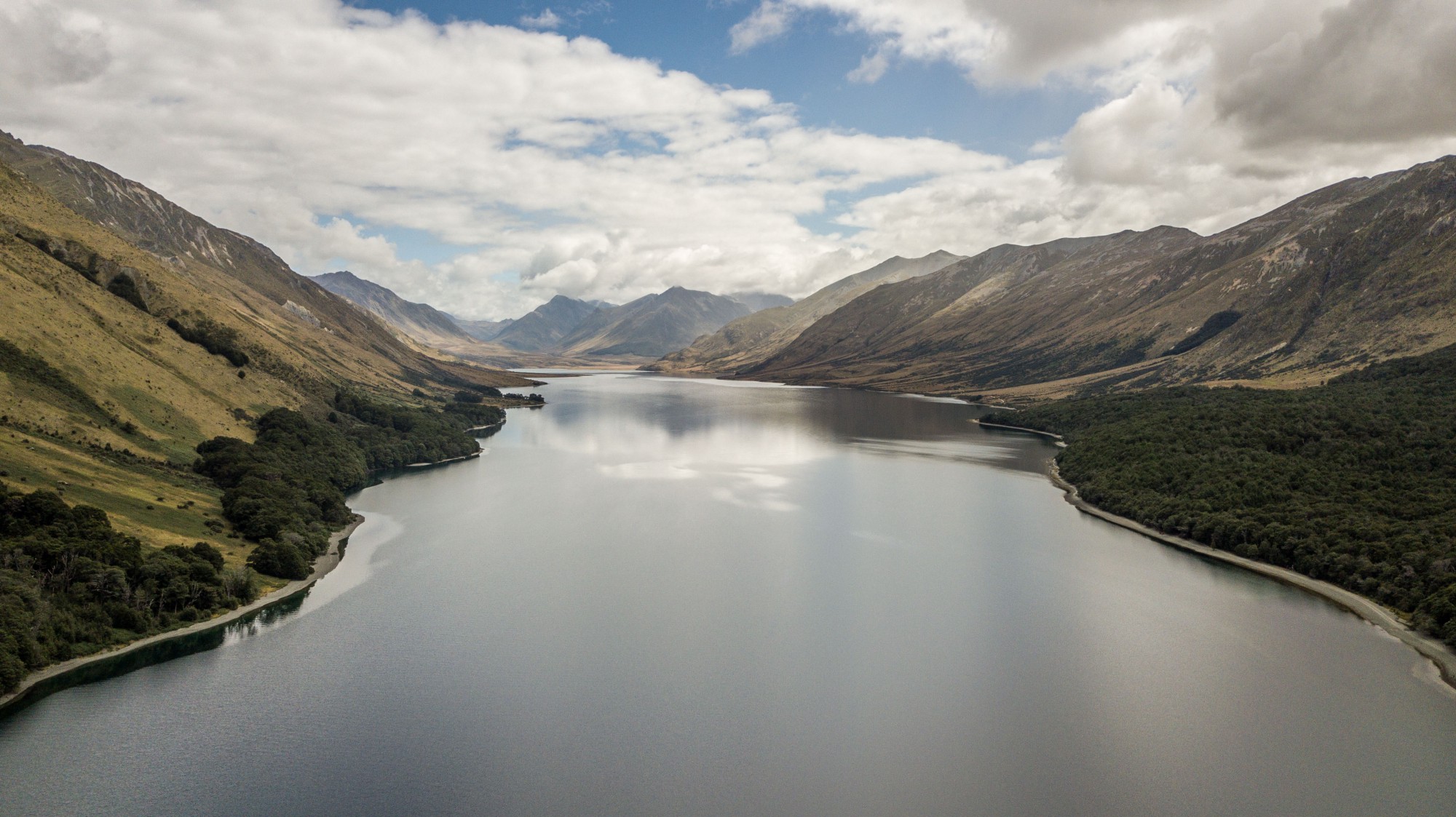
The Mavora Walkway section of the TA offers the first true taste of the South Island’s tall mountains when you’re northbound, entering the ecosystem of the Otago region’s drier climate. While there was no running water at the Mavora Camping Area the first night due to draught, the following day we hiked with rain for the first time since the start of our trek.

The beautiful aerial landscape of the Mararoa River along the Mavora Walkway section, surrounded by tussock.

The alpine landscape nearby the Greenstone Hut on the Mavora Walkway section. The hut is popular among TA hikers because the hut warden is a thru-hiker himself and because it’s maintained in an impeccable condition. The warden, Eiji Kitai, was inspired by the stories of all the hikers stopping at Greenstone and recently decided to take on the trail as well.

Walking in the Otago region toward Lake Wanaka along the Motatapu Alpine Track with hot, dry weather and 360 degree views of the beautiful landscape. We made our way to the Fern Burn Hut (top left) on a very sunny, hot day. Higher in the mountains some of the water tanks at the huts and the nearby streams had dried out. From above the Fern Burn Hut one can see the nearby Lake Wanaka on a clear day (bottom left).

When the trail gets hard, the sudden sight of an inquisitive South Island robin is guaranteed to make your day better and leave you with a big smile.

Arthur’s Pass National Park, on the Goat Pass-Mingha Valley section. The Goat Pass Hut (top left) has some of the most stunning views we’ve seen from a hut, and the nearby trail to the Greyneys Shelter parking lot crosses through peat bogs and tussock along a scenic boardwalk. This section of the Te Araroa is also used annually by the Coast to Coast Race which takes place in February. Bottom left: A fantail bird following the trail with us. They are a common company on the TA, and like the South Island robins, they are curious and get really close to examine the hikers. Bottom right: A storm was approaching over the mountains in the national park. While we were on the TA, the South Island saw the effects of heavy rains and strong winds from two ex-tropical cyclones. However, this year was one of the hottest and driest on record in the south, and many huts were running out of water.

Kea (Nestor notabilis) is an endemic species of alpine parrot, in fact the only species of alpine parrot in the world. Charming residents of Arthur’s Pass National Park and the surrounding areas, it’s estimated that only 3,000-7,000 kea are left in the wild. They are famous for approaching cars and people, attracted by sounds and anything sparkling, picking through everything with their strong beaks. There are many efforts underway to insure the survival of the species, and as visitors we can help by being responsible and not trying to feed or attract the kea to us. By visiting the website of the Kea Conservation Trust we can support their programs and register any kea sightings.

Top left: The Hope Kiwi Lodge located within the Lake Sumner Forest Park. Top right: The meadows around Hope Kiwi Lodge are filled with wild flowers and native butterflies. All we have to do to start noticing them is to pay attention to the world at our feet. Bottom: A massive storm was brewing over the mountains, as we were heading out to Boyle Village. The next morning strong winds and rain hit the west coast of New Zealand, causing damage and blocking traffic along Highway 6.

The TA crosses the Hurunui Mainland Island sanctuary, protecting one of the best preserved beech forest ecosystems of the Canterbury region. These were the liveliest forests we’ve witnessed along the TA, filled with bird songs that we didn’t hear anywhere else. “Mainland islands” in New Zealand are enclosed areas, either naturally or artificially, where the Department of Conservation and teams of scientists work to remove invasive species and restore the ecosystem to its original state, hoping to see a return of native bird populations. The Hurunui Mainland Island is home to the only known population of orange-fronted parakeets and a small population of yellowheads, allowing TA hikers to experience a piece of New Zealand’s nature as it used to be.


The TA crosses the Hurunui Mainland Island sanctuary, protecting one of the best preserved beech forest ecosystems of the Canterbury region. These were the liveliest forests we’ve witnessed along the TA, filled with bird songs that we didn’t hear anywhere else. “Mainland islands” in New Zealand are enclosed areas, either naturally or artificially, where the Department of Conservation and teams of scientists work to remove invasive species and restore the ecosystem to its original state, hoping to see a return of native bird populations. The Hurunui Mainland Island is home to the only known population of orange-fronted parakeets and a small population of yellowheads, allowing TA hikers to experience a piece of New Zealand’s nature as it used to be.

The short, steep side trail to the Travers Falls between the Upper Travers and the John Tait huts is, as the online trail notes remark, definitely worthwhile.

Top left: an alpine grasshopper taking in the sun nearby Lake Constance. Top right: Andreea descending from the Travers Pass. Bottom left: Impressive views of high mountains and dense beech forests are part of the beauty of Nelson Lakes National Park, which make it the favorite spot for so many hikers on the TA. Bottom right: “Vegetable sheep” covering some of the boulders in the Traves Pass. This is a type of cushion plant, living at high altitude on New Zealand’s North and South islands.
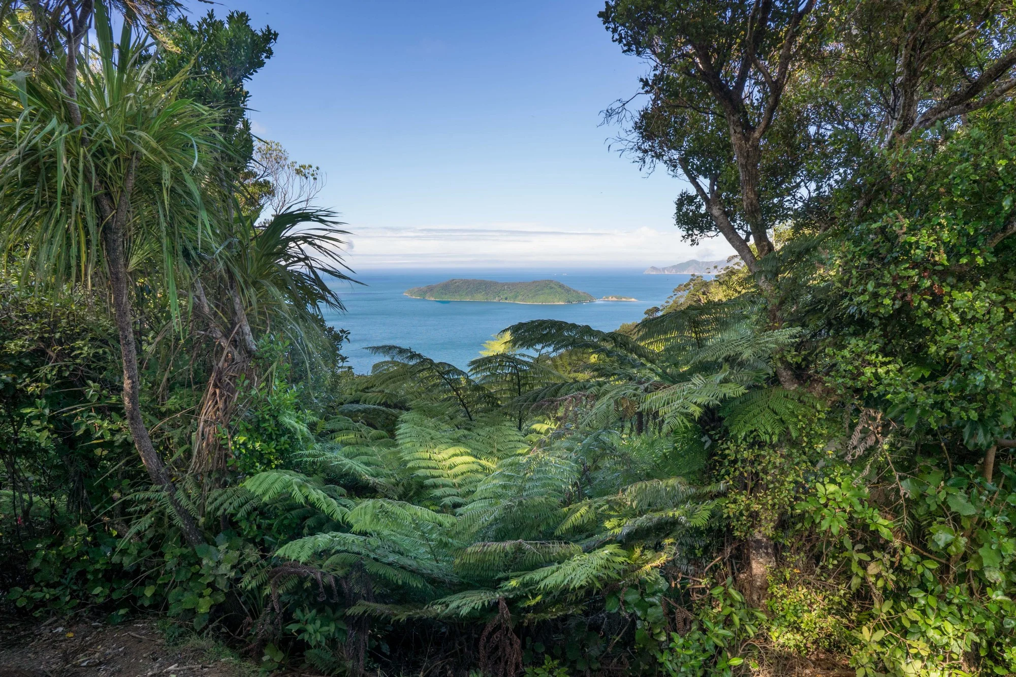
For those headed north on the TA, the Queen Charlotte Track is the last section on the South Island, before crossing the Cook Strait and continuing the journey on the North Island. It’s a three-day, 66 km trek in an area where the Department of Conservation (DOC) has formed a partnership with the Queen Charlotte Track Land Cooperative to allow access to trampers on private land. A special pass is needed and can be purchased at DOC centers in Picton or Nelson. The view in the above picture of the Queen Charlotte/Tōtaranui Sound is one of hope, because the island in the distance is the Motuara Bird Sanctuary. Between the 1770s and 1920 when it was declared a reserve, much of the tree cover was gone due to farming, while introduced rodents had decimated the birds. Now, almost 100 years later, it’s one of New Zealand’s bird paradises, with kiwis, native song birds, little blue penguins and king shags thriving due to intensive conservation efforts. The island itself can also be visited on day trips from Picton.
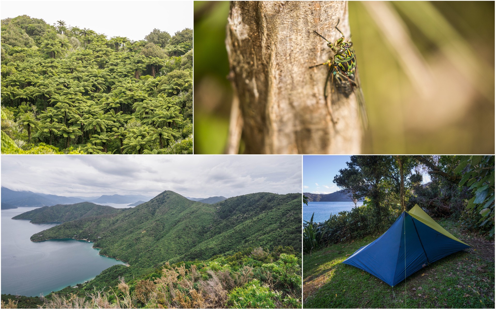
Top left: The ponga/punga, or silver tree-fern is a New Zealand national symbol and a common presence along the Queen Charlotte Track, especially in Punga Cove on the Queen Charlotte Track. These ferns can grow to 10 m with a crown reaching 4 m in width. Top right: The cicadas were active all day in February, their buzz filling the air and our ears constantly while on Queen Charlotte Track. Due to the loud noise produced by cicadas, we noticed a funny phenomena: the way we perceived the sound of the letter “s” was not normal anymore, which led to hearing everyone, including ourselves, speaking with a lisp. This was the source of much amusement, and sometimes frustration. Some residents along the Queen Charlotte Track even have a name for this: the “soundsy”. Bottom left: Getting closer to Picton, with breathtaking views of the bays below. Bottom right: Our dear tent matching the bright blue of the sea at the Schoolhouse Bay Campsite.

Left: A kererū or New Zealand pigeon on the Queen Charlotte Track. They are a common presence on the South Island, making a distinctive, loud sound with their wings as they fly away. At 55 cm (20 in) in length and over half a kilogram (23 oz), they are one of the biggest surviving species of pigeon in the world. Right: Weka are a sneaky and large flightless bird endemic to New Zealand. Curious and daring, they will approach tents and backpacks and carry away anything they can grab in their beaks. At the Schoolhouse Bay Campsite one weka left with the solar battery charger of one of the TA hikers, but he succeeded in retrieving it later from the forest next to the campsite. Though the numbers of weka have declined in many parts of New Zealand, the Marlborough Sounds where the Queen Charlotte Track is located remains one of their strongholds.


In the Iberá wetlands of northern Argentina lies an incredibly biodiverse ecosystem. In this inspiring interview with Kris Tompkins, she tells the story of how her organization, Tompkins Conservation, has worked to restore and rewild the land, bringing back extirpated species and involving local communities in the conservation of what is now one of the largest protected areas in Argentina. Listen to her story and travel from home to this beautiful and remote corner of the planet where wildlife has been returning in large numbers.